Just before winter hit last year, I loaded up my bike and some cameras and headed to the Gifford Pinchot NF for what was sure to be the last high altitude Mt ride of the year.
Weather forecast showed a huge storm coming in later that night and the weather man had promised a few feet of snow in the Cascades. I had the day off and was itching to ride and shoot some pics, so by 5am I was all loaded up and on the road.
Having ridden and hiked in this area many times before, I was really looking forward to heading back. The Gifford Pinchot / Mt Adams area is such a beautiful place. The trails run across many hi ridges with amazing views, and there are also quite a few lakes for camping and fishing. In the middle of summer the misquotes are brutal, but come Fall, you would be hard pressed to find a more peaceful, scenic place anywhere in the country.
After about a 2 1/2 hr drive from my home in West Linn, I made it to my staging area for the day at
"Lower Lewis River Falls"


As soon as I arrived, I grabbed my camera and headed down to the falls, hoping to get there before the sun got to high and the hard contrast ruined the shot.
The falls can be shot from many angles, as the trail offers lots of different views, but this location was my favorite. The surrounding trees and bushes really help to frame the falls and add some nice depth to the image.
While I for sure wanted to get some ridding in, photography was my main focus for the day. So I continued to shoot around this area for a little while. But once the sun came up, I packed up a pretty full load of camera gear, along with a tripod into my backpack, hopped on my bike and headed for the hills.
The motorcycle trails in the Mt Adams area offer about as good of riding as anywhere in the country. The trails are steep and at times very difficult and dangerous, but you are reworded with scenery on a grand scale. Which of course, is why I chose to go there. Great ridding along with amazing scenery makes for a happy adventure photographer!


Once I felt I had all the exposures I needed, I packed up and headed back to the truck. It was a long cold ride but I was excited to get off the Mt before the storm hit. Plus, I couldn't wait to get back and create the final image from all the exposures I had made. I new it would take a little while at the computer, but I felt the final image could be really nice.


My plan for the day had me leaving the falls and heading East to a nice viewpoint near Sunrise Peak, and then even more East to Takhlakh Lake. I would be hitting a mixture of roads and trails and planned on getting to the Lake a little before sunset, so if the conditions were good, I could get in some nice late light shots of the Mt.
Well, right off I realized I had to change my plain a bit. I was ridding solo and had quite a load of gear, so hitting some of the expert trails was not going to be such a good idea, especially with a major storm coming in later that night. So, after hitting a few of the lower easier trails, I stuck mostly to the back country roads and zig zagged my way over to Sunrise.

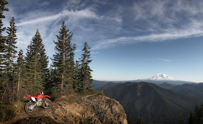
Pulling off the twisty gravel road and onto trail #262, there is a really nice steep section of single track that travels about a mile up through the trees and pops you out on the side of a cliff, rewarding you with an amazing view of Mt Adams.
Once there, I shot this and a few other stock images, then figured I better get moving if I wanted to get down to Takhlakh Lake before sunset.
I arrived a little later than I had hoped, and as I pulled up to the lake, the sky and the Mt were already bathed in a beautiful late light. There were some really nice clouds and the light on the Mt was amazing.

But, I new the light would be gone quick, so I didn't waist any time. I grabbed my gear, headed to the edge of the lake and shot a few images right away that didn't need any setup. I didn't want to miss out on the nice light and figured something simple would be better than nothing.
Once I new I had a few good shots in the bag, it was time to set up the shot I had planned on all along, but was already a bit late for when I first arrived. I had all the gear I needed, but by getting there a little late, I new it would require a little photoshop trickery later in post. Not to be fooled by mother nature, I went straight to work.

First off, I needed to set it up quick and get a shot off while there was still a little light on the trees and nice light on the Mt. With the camera on a tripod, I shot the dark exposures first so I didn't loose the light, and bracketed in 1/3 stops with the shutter speed. It's important when creating a layered image this way that you use the shutter speed, not the aperture for the exposure bracket. Changing the aperture can cause the multiple images to not aline correctly.

As you can see here, since I arrived a bit late and the sun was gone from the foreground, there was a massive exposure difference between the foreground and the background. So, once I had the dark exposure for the sky and the Mt, I then shot a much lighter exposure for me, the bike and the campground. Again, I shot in 1/3 stop brackets so I could later pick the best exposures to blend together.
Once I felt I had all the exposures I needed, I packed up and headed back to the truck. It was a long cold ride but I was excited to get off the Mt before the storm hit. Plus, I couldn't wait to get back and create the final image from all the exposures I had made. I new it would take a little while at the computer, but I felt the final image could be really nice.

Back home, I opened up a few different light and dark exposures in
onOne software's "Perfect Layers".
I was quickly able to blend the images together and come up with a final image that, while on location, my eyes could see, but just simply could not be captured in one exposure.
Then once I had the base image done, I went in and stylized it a bit with some saturation and contrast to give it a little punch, then added a simple border to frame it up nice. Overall, I was really happy with the day and the images I came back with were a nice addition to my stock files.

How to get there......
The "Lower Lewis River Falls" is located on HWY 90 (FS90) about 1 1/2 hr east of Woodland WA.
There is a nice campground there and its a great spot to stage for motorcycle trails (trail #80) as well as great Mt biking and hiking on the Lewis River Trail.
http://www.lewisriver.com/falls.html
Takhlakh Lake is about another hr or so further east off of NF23
http://www.recreation.gov/camping/Takhlakh_Lake_Campground/r/campgroundDetails.do?contractCode=NRSO&parkId=71647&topTabIndex=Search
The Sunrise Peak Trail #262 is another hr, and a bit farther north of the lake off NF23
http://www.fs.usda.gov/recarea/giffordpinchot/recreation/ohv/recarea/?recid=31426&actid=93
No comments:
Post a Comment